فاس نيوز ميديا جريدة الكترونية جهوية تعنى بشؤون و أخبار جهة فاس مكناس – متجددة على مدار الساعة

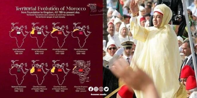
A recent historical chart reveals the fascinating territorial evolution of Morocco from its foundation as a state in 789 AD to the present day. This chart illustrates the significant geographical changes that Moroccan territories have undergone through eight major historical periods.
The journey began with the Idrisid Sultanate (789-974), which formed the nucleus of the Moroccan state. It was followed by the Almoravid Sultanate (1040-1147), which expanded southward. Then came the Almohad Caliphate (1147-1269), during which Morocco reached its greatest territorial extent.
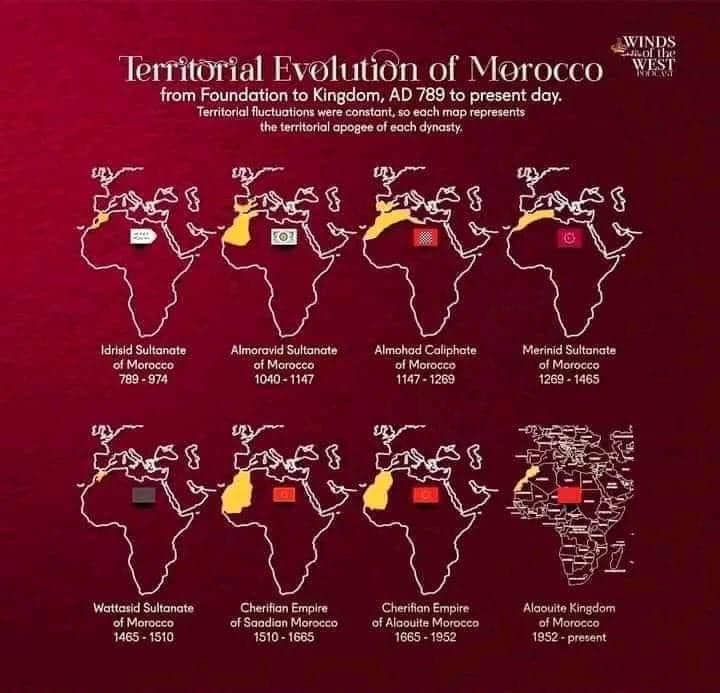
The Marinid Sultanate (1269-1465) continued to maintain most of these lands, before the geographical area shrank during the Wattasid era (1465-1510).
The period from 1510 to 1659 saw the rule of the Saadian Sharifs, followed by the rule of the Alaouite Sharifs from 1659 to 1912. Finally, the modern Kingdom of Morocco was established in 1956 and continues to the present day.
This historical chart highlights how Morocco’s borders evolved and changed over the centuries, focusing on the periods that saw the maximum territorial expansion for each ruling dynasty. It provides a comprehensive view of Morocco’s rich geographical history, highlighting its evolution from a small sultanate to a modern kingdom with stable borders.