فاس نيوز ميديا جريدة الكترونية جهوية تعنى بشؤون و أخبار جهة فاس مكناس – متجددة على مدار الساعة

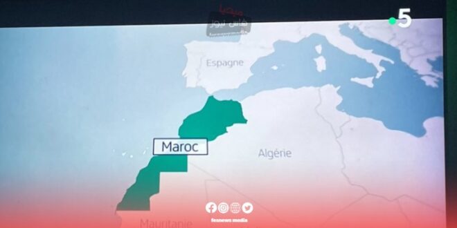
In the wake of France’s recognition of the Moroccan status of the Sahara, French public media outlets have begun to gradually adjust their maps, replacing old inaccurate maps of Morocco with updated ones.
This move comes as a direct reflection of France’s new position on the Sahara issue, as France recently announced its recognition of Morocco’s sovereignty over the region. This change in map drawing is considered an important step towards unifying the geographical representation of the Kingdom of Morocco in French media.
These adjustments are expected to cover various media platforms, including television, newspapers, and websites belonging to the French public sector. This shift reflects a change in French media policy to align with the official government stance.
Observers view this step as contributing to the consolidation of the new vision of Morocco’s geographical and political situation in French public opinion. It may also influence future media coverage of the Sahara issue.
It is worth noting that this change in map representation comes in the context of evolving Moroccan-French relations, and is considered a positive step from Morocco’s perspective in its diplomatic efforts to enhance international recognition of its sovereignty over the Sahara.
This development is seen as significant in shaping public perception and understanding of the region’s geopolitical landscape, marking a notable shift in how the Sahara issue is visually represented in French media.